The Delaware Water Gap National Recreation Area in Pennsylvania and New Jersey is a great place for a variety of outdoor activities, including hiking. This area is filled with waterfalls, including some of the most popular waterfalls in Pennsylvania. Some of the waterfalls are easy to access, and others are a little more difficult.
The Hornbecks Creek Trail is not one of the most popular spots in the Delaware Water Gap, but it is a beautiful hike that features a few different waterfalls, in addition to the surrounding forest.
Although this trail is not all that popular or crowded, unlike some other trails in the area, this one is an official trail that is maintained by the National Park Service. However, the trail has been impacted in recent years by erosion and storms that have washed out part of the trail. As a result, what used to be one longer out-and-back hike now must be done in two separate sections if you want to reach all of the waterfalls on the trail. The middle section of the trail has been closed by the NPS as a safety precaution.
Fortunately, you can still reach all of the main attractions along the trail (the waterfalls). The only difference is you’ll have the minor inconvenience of driving about 5 or 10 minutes from the lower end of the trail to the upper end, or vice versa.
There is no shortage of waterfalls in the Pocono Mountains. Here are some others that have already been featured on Loaded Landscapes:
Hiking the Lower Portion of the Hornbecks Creek Trail
Probably the main reason this trail is not more popular is because most visitors simply don’t know about it. The only signage for the trail is one sign by the lower parking area. That parking area is located along US 209, which is the main road that runs along the Pennsylvania side of the Delaware River. You can use this road to reach many of the other waterfalls and trails in the Delaware Water Gap.
You’ll see the sign for Hornbecks Creek Trail, and a small parking area is on the opposite side of the road from the trailhead. The parking area is on the east side of the road (the river side), and the trailhead is on the west side. The GPS coordinates for this parking lot are: 41.187221, -74.885025
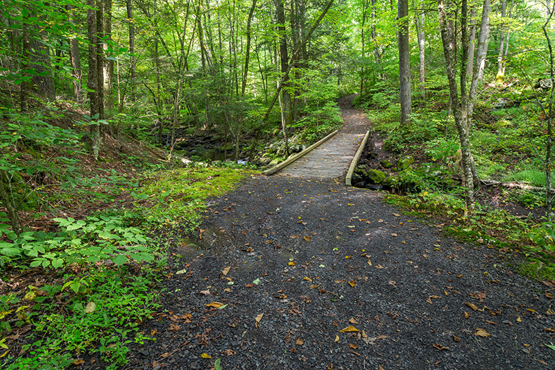
The trail starts along a gravel road that heads away from the river and into the forest. Although it leaves the gravel road fairly quickly, the trail at this lower section is pretty wide in most places, and not all that steep.
→ See More of the Best Places to Photograph in Pennsylvania
Near the beginning of the trail
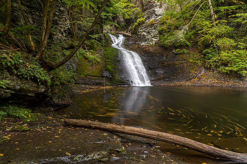
Along the trail you’ll get some views of the creek, and, of course, the surrounding forest. There is one main waterfall on this lower section of the trail, and you’ll need to hike about 1 mile to reach it.
Eventually the trail leads down some stone steps, and then before long you will reach the waterfall. After the steps the trail runs right along the edge of the creek. In times of high water I’m not sure how much of the trail will be dry. You may get your feet wet if the water is high.
The lower trail by the creek continues to a nice view of the waterfall, while the trail also breaks off and heads uphill. Somewhere beyond the waterfall the trail is closed. I didn’t continue beyond the waterfall, so I don’t know how much further it goes until the trail is closed.
The waterfall here is fairly impressive and picturesque, considering Hornbecks Creek doesn’t normally have the highest volume of water flowing. There are some rocks and logs near the bottom of the falls that provide some dry ground to get a view for a photo (again, this may be different when the water is higher).
Since this is the only waterfall on this lower section of the trail, you can head back to your car when you are done here.
Hiking the Upper Portion of the Hornbeck’s Creek Trail
While the waterfall on the lower portion of the trail is nice, the upper section offers much more, in my opinion. There are 3 main waterfalls with several other cascades, and you only need to hike about 1/3 of a mile to see it all.
From the lower parking area you can drive a few miles to a smaller pull off area along Emery Road. There is room for only 2 or 3 cars here, but not many people know about it, so you should be able to park here. The GPS coordinates of this parking area are: 41.196100, -74.908815
This is right next to a small bridge that crosses Hornbecks Creek. Cross over the creek and find the small trail that leads along the creek. You will be walking downstream with the creek to your left. This section of the trail is unmarked, but it’s not difficult to find your way. It’s kind of challenging in some places to know where the trail is. There are some paths that lead down to the creek, but they can be very steep in some places.
This section of the trail has a much different feel than the lower section. The forest is not quite as thick here, and the elevation changes much quicker. The trail is also narrow with some steep drops in places.
You’ll reach the first waterfall in just a few minutes of hiking. The first waterfall is not very tall, but still pretty. You can get a decent view by stepping out onto some rocks.
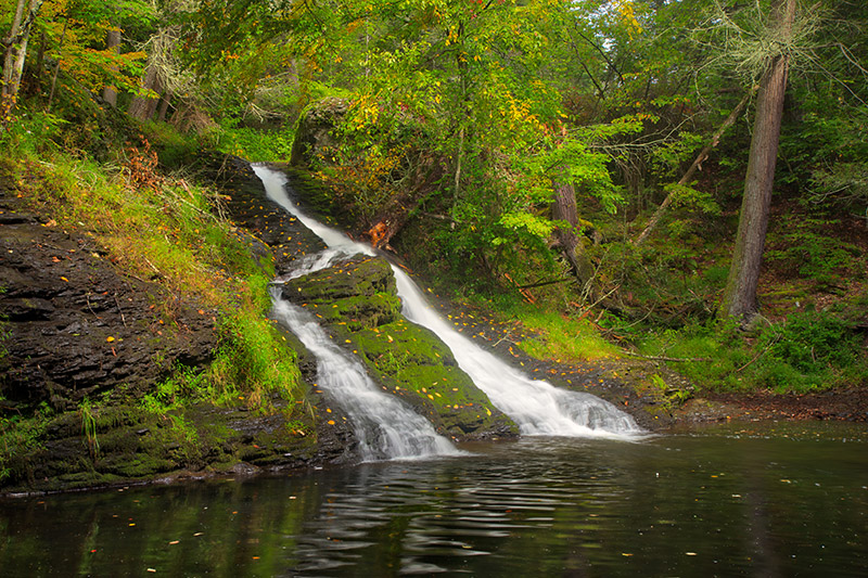
Continuing beyond that first waterfall, you’ll quickly come to another significant waterfall. This one is down in a gorge. You can easily see it from above, but getting down to water level can be a little more tricky. I was able to work my way down, but didn’t like the view very much, so I didn’t bother taking a photo here.
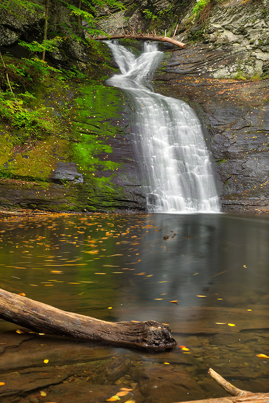
After that waterfall you can continue a short distance and you’ll reach the third waterfall, which is sometimes called Indian Ladders. This one is the highlight of the trail, in my opinion. There are some stairs that lead down to the bottom of the waterfall, and there are lots of rocks here. Unless the water level is very high you should have no problem walking around and getting different vantage points without getting your feet wet.
The photos in this post have been processed with the Landscape Legend Lightroom Presets. You can learn more about Landscape Legend here.
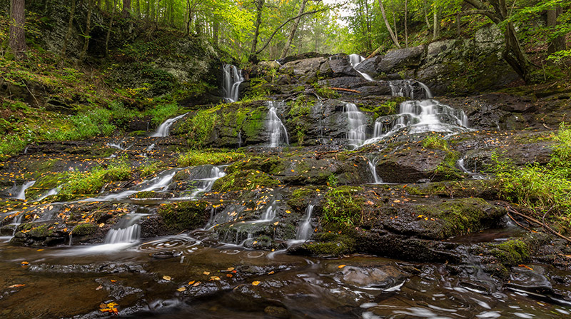
This is a really unique and beautiful waterfall the way it cascades down the rocks in so many different sections. Although there are much bigger and more powerful waterfalls in the Delaware Water Gap, this is one of my favorites.
During my recent trip (mid September) the water level wasn’t very high. I’ve seen photos of this waterfall in the spring, and it looks even better. I’m putting it on my list of places to visit next spring.
Once you’re done with this waterfall you can head back to your car.
If you decide to visit Hornbecks Creek you can probably hike and photograph both sections of the trail in about 2 hours. If you’re working with limited time I would recommend the upper portion. With more waterfalls it is the more interesting section, and it’s also the shorter hike. That being said, the lower portion is also a nice hike.